Satellite-Based AGB/CHM Estimation Model
Overview.
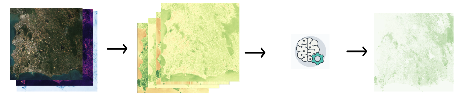
This project is an UNET probabilistic deep learning model for estimating forest structure data such as canopy height/above ground biomass from satellite-based data such as sentinel 1 , sentinel 2 and GEDI data.
Here you can find all relevant information about this project in this repository.
Repository
Source code available here
AGB Output Result , Model Checkpoint , Data
- AGB baseline output mean , variance result from paper are locate at Varuna GCS
Path : varuna-data-nonprod-analytic/biomass-estimation-project/vm-backup/AGB_model_data/ensemble_final_output
- Ensemble model checkpoints are locate at Varuna GCS
Path : varuna-data-nonprod-analytic/biomass-estimation-project/vm-backup/AGB_model_data/best_checkpoint/ensem1
- Sampling training data (train/test/val) are locate at Varuna GCS
Path : varuna-data-nonprod-analytic/biomass-estimation-project/vm-backup/AGB_model_data/train_data
Prerequisites
Some background in geospatial data analysis is require to work through the project. For new comer who does not have geospatial background, do not skip this step.
PyGIS - Open Source Spatial Programming & Remote Sensing will introduce you to the methods required for spatial programming and make you getting familiar with concept like raster, vector, coordinate reference systems
First-timer
If you don’t have any clue about this project , go through Theorem section to look for brief overview of the project
It will guide you from background and details literature , methodology such as
- Problem assetment of the project
- Biomass / Aboveground Biomass definition
- Remote Sensing process
- Model Methodology
Dev/ML
Explore Data and Model section for implementation detail of the project
User
- Prediction Section will walk through step-by-step how to use model to produce outcome.
- Application Section descibe how to interpret the output prediction and get correct result.